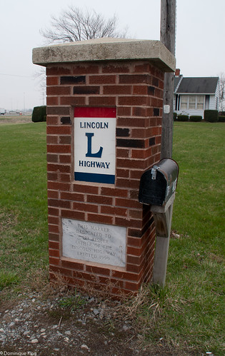
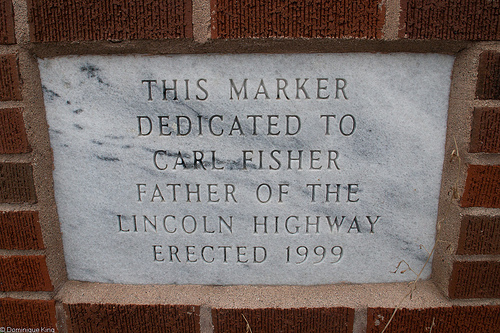
This marker in Beaverdam, Ohio, is one of many along the Lincoln Highway marking its intersection with the Dixie Highway. Considering the number of highway alignments over the years and existence of multiple Dixie Highway routes, the multiple claims of being "The Crossroads of America" may be true, but Beaverdam's claim to the title seems particularly good.

So, who was Carl Fisher and what is his connection to the two highways?

The Indiana-born Fisher established a bicycle repair shop with his two brothers in 1891 when he was 17 years old. Bicycles' popularity waned as automobiles became increasingly popular in the early 1900s. Fisher followed the trend, opening an auto dealership with legendary auto racer Barney Oldfield.
Fisher's gift for promotion became apparent early as he staged events like riding a bicycle on a tightrope suspended between two tall buildings in downtown Indianapolis and attaching a car to a hot air balloon to fly it over town to promote his businesses.
In 1909, Fisher and three other investors put up $250,000 each to build an auto proving ground, the Indianapolis Motor Speedway. The raceway was a 2-1/2 mile track paved with crushed stone, but the stone track quickly proved deadly for auto racing. Organizers shut down the track, reopening it in 1911 as a brick-paved track (hence the nickname, "The Brickyard").
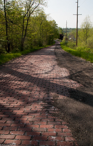
Fisher felt that promoting better roads was the best way to drive the popularity of automobiles. He also sold the idea of improved roads as a way to stimulate the country's agriculture and commerce.
In 1910, there were 180,000 registered motor vehicles in the country. The nation had 2.2 million miles of rural roads at the time, but fewer than 9 percent of those were "improved" in any way like paved with gravel or bricks, graded or oiled.
Fisher envisioned a transcontinental highway from Times Square in New York to San Francisco's Golden Gate, constructed in time to drive it to San Francisco's Pan American Exposition in 1915.
Fisher gathered $1 million in contributions within a month of announcing plans to develop the coast-to-coast highway. Celebrity contributors like Teddy Roosevelt, Thomas Edison and then-president Woodrow Wilson lent support to the project, although others, like Henry Ford, felt the government should pay for roads, rather than private investors.
Supporters formed the Lincoln Highway Association (LHA) in 1913, naming Packard Motor Car president Henry Joy to head the group headquartered in Detroit. Communities vied to be on the route as planners considered the need to connect major cities, supportive communities, scenic landscapes, and historic sites while plotting the most direct cross-country route.
The Lincoln Highway originally went through 13 states and measured 3,389 miles. Much of the route took in already existing roads, although less than half of them were improved roadways.
The LHA sanctioned suggested routes, designated existing roads with signs, published guidebooks for motorists and formally dedicated the route on October 31, 1913.
A LHA guidebook from 1916 advised motorists that driving the route was "something of a sporting proposition" and they could expect to take 20 to 30 days to make the coast-to-coast trip while averaging 18 miles per hour.
The LHA built a few short stretches of road, but organizers realized that the best use of their money was to promote and encourage travel along the route and build public demand for better roads funded by State, county and local officials.
By 1913, Fisher became enamored with a Florida swamp that he would eventually develop into one of the nation's most popular resort areas-Miami Beach.
Fisher proposed a new highway to bring Midwestern snowbirds to Florida and spur development of Miami Beach.
Competition among communities for a place along the highway was fierce, and it eventually developed as two largely parallel north-south routes. The Dixie Highway included over 5,700 miles running as far north as Canada and south just past Miami.
In the mid-1920s, about 250 named highways criss-crossed America. Government officials suggested a standardized system of numbering routes to alleviate confusion.

In 1925, highway officials proposed designating the Lincoln Highway as U.S. 30 along much of its route in an effort to gain the support of the influential LHA. Today, much of U.S. 30 is a divided, limited-access highway, although much of the original Lincoln Highway route, and its 1928 realignment, still exist.
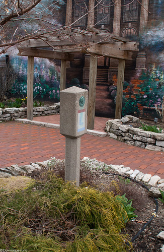
The LHA staged one last promotion before disbanding in 1928. It sponsored a nationwide contest to design Lincoln Highway markers, with landscape architect Jens Jensen of Illinois winning with a design for concrete mile markers featuring a bronze head of President Lincoln, the highway's logo, and directional arrows.
In 1918, Boy Scouts placed 3,000 of the markers along the route. You can some of these classic mile markers, like the one we found sitting in its own little pocket park along the main road in Van Wert, Ohio.

The Dixie Highway is a little tougher to follow today, although it still exists as a named street in some places Pontiac, Michigan, not too far from my home. Many consider I-75 as the "modern Dixie Highway".
The marker we found in Beaverdam, Ohio, is just west of I-75. Lima, Ohio, was the original point of intersection with the Lincoln Highway and the eastern branch of the Dixie Highway. A 1919 re-routing of the Lincoln Highway brought the intersection to Beaverdam, where the paths of both highways followed the town's Main Street for a short way.
The LHA reformed in 1992 to promote and preserve the Lincoln Highway and its history. The Mid-Ohio chapter of the LHA placed the Beaverdam pillar on the original base of a previous marker at the site in 1999.
Check out my story Cruise into Ohio's Canton Classic Car Museum. The museum sits within six blocks of the Lincoln Highway, housed in a former bicycle repair shop that became an auto repair garage when the highway first rolled through town in 1913.
Want to learn more about the America's first coast-to-coast highway? Check out The Lincoln Highway: Coast to Coast from Times Square to the Golden Gate by Michael Wallis.
© Dominique King 2011 All rights reserved


Comments